

Great power competition did not disappear with the end of the Cold War. Nowadays, tensions are rising between the USA with Trump’s zero-sum-gain policies, Russia with its aggressive behaviour toward its neighbours, and finally China with its restored military and economic status.
This competition takes many forms. Trade wars, alliances and propaganda campaigns are one. The military competition is also going strong, with each side trying to improve on its weapons and to introduce game-changing new capabilities. Among those capabilities is a new class of high-speed projectiles that these three countries are developing: hypersonic vehicles. They are also looking at ways to counter them, and that starts with detecting and tracking them, which is best done from space. While this last aspect is not strictly Earth observation, it still consists in sensors carried by satellites looking at the Earth or very close to it, so we will broaden a bit the usual scope of this site. We will be back to our regular scheduled programming on Earth observation for the next articles though. So for now let’s look at how hypersonic vehicles can be detected and tracked from space.
This article has four parts:
- What are hypersonics ?, presenting more background on these weapons
- Current missile detection systems, looking at missile-warning satellite constellations in geostationary orbit or lower
- Back to hypersonics, applying the lessons learned from the existing systems to try to design possible architectures to detect hypersonic vehicles, depending if they are hot or cold targets
- Conclusion
What are hypersonics?
Whereas a supersonic vehicle flies above the speed of sound (Mach 1, around 1000km/h or 650 knots), a hypersonic one flies above Mach 5. But it not only the speed that makes hypersonics attractive: indeed, ballistic missiles routinely achieve speeds of up to Mach 25 and are 1960s technology. The true appeal of hypersonics is the combination of speed and maneuverability, which makes them extremely difficult to defend against, and allows for compressed engagement timelines against elusive targets.
Hypersonics is an umbrella term actually covering two different technologies: hypersonic cruise missiles, and boost-glide systems. The RAND corporation published a report and an accompanying video on their differences and the challenges they pose:
Hypersonic cruise missiles are an evolution of current air-breathing cruise missiles, the most well-known probably being the US Tomahawk, which flies subsonically and relies on low-level flight to avoid detection and interception. Other nations have developed highly supersonic cruise missile, such as the Russian/Indian BrahMos or the French ASMP.


However, speeds above Mach 5 are unheard of for such missiles. They would enable extremely quick reactions when an interesting target is detected: at Mach 1, crossing 1000km takes an hour, but it only takes 12 minutes at Mach 5. This means the target has less time to disappear, and as a bonus, the missile is very hard to intercept at that speed, as long as it does not fly on a predictable path. Typically, hypersonic cruise missiles would be powered by a ramjet or scramjet, which can be though of as high-speed versions of conventional jet engines. The USA, Russia, France, India and probably China are working on such missiles.

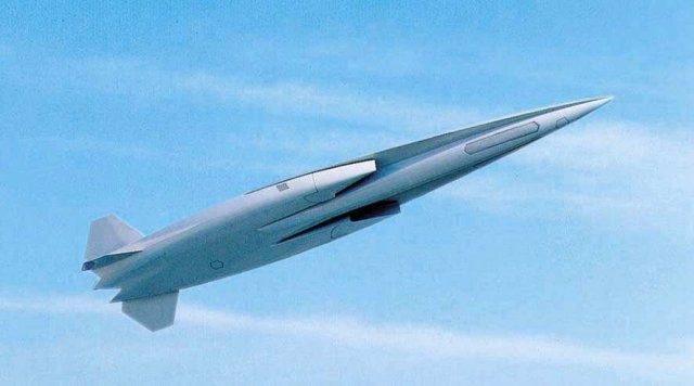
Hypersonics glide vehicles are something entirely different. They are launched by a ballistic missile and are completely unpowered after separation. However, instead of flying on a predictable ballistic arc like traditional reentry vehicles, they dive back in the atmosphere. There, they experience drag, which slows them down. However, due to their shape, they also experience aerodynamic lift, which allows them to glide on the atmosphere, and counterbalances their weight. Thus, they can fly as far if not further as a warhead on a ballistic trajectory launched on the same booster.

The first benefit of such a trajectory is that they stay closer to the ground, as their altitude is around 30km to 100km, so it is harder to detect them from the ground: radar and optical sensors being blocked by the curvature of the Earth, they can approach their target without being detected until the last moment, which makes defending against them much more complicated:
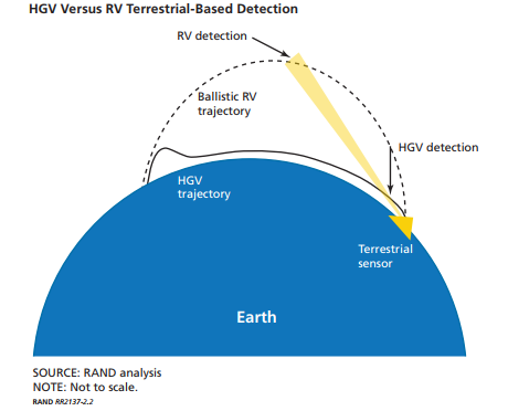
The maximum radar detection range against a vehicle flying at 30km is 700km. Also, because of they maneuverability, glide vehicles do not have to fly on a straight line: they can take the long route around radars or interceptors to avoid engagement, or to hide their true target:


Russia has even developed and plans to field shortly a hypersonic glider called Avangard, specifically to defeat US antiballistic systems:
As a final point, hypersonic gliders are harder to intercept because the atmosphere in which they evolve is thin but not negligible: it causes a lot of heating on anything flying fast in it, so the traditional infrared sensors used by interceptor missiles would be blind.
Currently, at least three countries are looking into gliders: the USA (both the Navy and the Air Force), Russia and China.

Current missile detection systems
This is not the first time a dedicated early warning system has to be developed to counter a new weapon. During World War II, Britain set up a line of radar to defeat German bombers. Closer to our time and more relevant, the introduction of the intercontinental ballistic missiles in the 1960s by both the USA and the USSR saw both sides build long-range early warning radars.
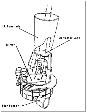
However, radars are limited by the curvature of the Earth and provide only a limited warning time, which was a military issue. To address this, the USA worked on satellites that would detect the heat released by the missiles’ engines. After a difficult research phase, they launched the first MIDAS (for Missile Defense Alarm System) in 1960. MIDAS was to be a constellation of satellites in polar orbit, orbiting at a few thousand kilometers up, but it never reached an operational capability. However, it proved that the infrared detectors of the time were good enough to detect launches.
The geostationary constellations
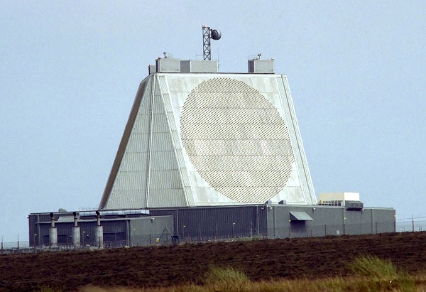
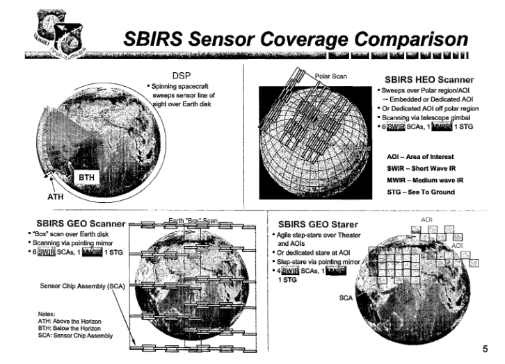
MIDAS was succeeded by DSP (Defense Support Program). DSP had a first launch in 1970 and was a constellation of typically 6 (3 primaries+ 3 backups) satellites in geostationary orbit. This orbit provided a constant view of a third of the globe to each satellite, making the detection of transient infrared events easier and allowing them to play a useful role 100% of the time.
From a technical point a view, DSP satellites were spin-stabilized, and used their rotation to scan the Earth every 10 seconds. The sensor consisted in an infrared telescope and linear detector that imaged a radius of the Earth’s disk.

DSP not only successfully detected ICBM launches, but was sensitive enough to detect tactical missiles and even Soviet bombers on afterburner. The reference book on DSP is Jeffrey T. Richelson’s America’s Space Sentinels: The History of the DSP and SBIRS Satellite Systems
The USSR developed a similar system called Oko, with a first launch in 1972. However it used mostly Molnya orbits instead of geostationary, and took a lot more time to become operational.

After 30 years of operations, DSP was eventually replaced by SBIRS (Space-Based InfraRed System). The process was long and costly, coming a few hundred percent over budget. SBIRS retained the concept of having satellites in geostationary orbit, and also added infrared sensors presumably carried by US signal intelligence satellites in Molnya orbit for better polar coverage. However, it did away with the spin stabilization and the DSP sensor design. Instead, it uses a back-and-forth scan for wide area coverage, and a staring sensor for high-revisit coverage over areas of interest.
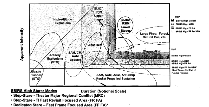
SBIRS’ manufacturer, Lockheed Martin, has published a instructive video comparing it to DSP and showing the sensor modes and the constellation architecture:
SBIRS’ improved sensors allow the detection of even fainter and faster events, such as anti-air missile launches:
Low-orbit systems
Nevertheless, even SBIR’s exquisite capabilities, nor those of its OPIR planned successor, are enough for the United States. They can only detect missiles with their engines firing, which occurs for only a small part of their flight. For the most part, the warheads and the bus that carries them are either completely passive or make slight course corrections, so their heat signature is very small: they go from room temperature at launch to thermal equilibrium with their environment, so they have very little temperature difference compared to the Earth’s infrared background. This means that they are not detectable over that background, so a satellite can only see them when they are over the Earth’s horizon.
Furthermore, the USA is not only interested in tracking missile warheads, which it can do by cueing a radar to the initial detection provided by SBIRS. Rather, it would want to differentiate the warhead from the decoys that will likely be launched with them and have a similar radar signature. This means detecting small differences in infrared signatures of small objects, a task best performed by satellites that are not too far away. This midcourse discrimination problem is central to all missile defense architectures, from Reagan’s Strategic Defense Initiative to nowadays limited US antiballistic capability. Without it, it is easy to defeat the system with simple decoys, as acknowledged in the US National Academies of Sciences’ Making Sense of Ballistic Missile Defense report: “Whether decoys can be readily discriminated, particularly in the face of antisimulation techniques, remains a contentious subject however.”
The initial plans for SBIRS included a low-orbit component to perform that midcourse tracking and discrimination task. However, its scope was reduced to two proof-of-concept satellites called STSS, Space Tracking and Surveillance System, launched in 2009.

Northrop Grumman made a explanatory PR video on STSS’ purpose and operations:
How low can you see?
Since cold objects can only be detected above the horizon, over the even colder background of space, what exactly the horizon means is an important question.
Since the atmosphere is not completely transparent to infrared, especially in the denser, lower layers, the view of missile tracking sensors is blocked not only by the ground but also by the atmosphere. So the horizon is a bit above ground level, and the lower it is, the greater the coverage of the missile tracking sensor. The USA launched at least two missions, MSX and TIMED, to investigate how low its sensors could see and optimize STSS’ design. For cold objects, the horizon seems to be lower than 80km using 1990s technology, and maybe down to 40km in some relatively large spectral bands. 

Detection below the horizon was considered, using very narrow spectral bands that are transparent down to 10km, so that flying objects remain visible but the ground and low-altitude clouds are masked and do no create false detections. However, using narrow bands greatly reduces the signal from the targets and was seemingly not retained on STSS.
Back to hypersonics
So after this review of the various methods of infrared detection of missiles, what can be deduced about potential architectures to detect and track hypersonic vehicles?
The first thing is that the optimal architecture will depend a lot on if the targets are hot and can be seen below the horizon, or if they are cold and need to be above the sensor’s horizon. So the infrared signature of both hypersonic cruise missiles and boost-glide vehicles has to be guesstimated.
Hot gliders
For gliders, this NASA document on material developments for the HTV program gives a temperature of 3600°F, or about 2000°C or 1700 K. That’s quite far from the surface temperature of roughly 300K, so these can be considered hot and detectable below the horizon. A very detailed modelling of a US hypersonic glider done by Chinese scientist found that in the MWIR band, it emitted an intensity of 6e4 W/sr, whereas 1km² of Earth background at 300K emits 1.866e6 W/sr. A 1°C local variation in the same background emits 1.799e6 W/sr, so the difference in signal due to the non uniformity is 6.7e4 W/sr, which is similar to the signature of the glider. That means suppression of the background through dedicated signal processing is critical. A promising approach is to use the dynamics of the background over time: it is unlikely 1km² of Earth gains 1°C over a fraction of a second, which is the time it takes for a glider to cross 1km. Nevertheless, other phenomena like solar glint might still create false positives even with temporal processing, making sensors with higher spatial resolution attractive.
So for the gliders, architectures in GEO similar to DSP/SBIRS can be envisioned. However, as seen above, because the gliders are small they do not emit much thermal energy even if they are hot, so their overall signal will be much fainter than that of an ICBM launch. This is supported by the recent statement of US Undersecretary of Defense for Research and Engineering Michael Griffin, who said “Hypersonic vehicles are hard to see from high orbit because they are not as bright. They’re a factor of 10 or more dimmer than strategic missiles. So we have to get closer to see them and track them.”
So in all likelihood, the US answer would consist in something akin to the initial plan for STSS, a constellation of satellites in low Earth orbit with below-the-horizon sensors. Depending on their orbit, they could also pull double-duty as warhead tracking satellites if their are equipped with an above-the horizon sensor optimized for cold targets too. Having a constellation with a relatively large number of satellites would be consistent with the US push for disaggregating their space segment to be more resilient to counterspace threats.

Using an orbit similar to STSS, a below-the-horizon sensor could cover an area more than 7500 km wide, so a ballpark estimate for constellation size would be at least 6 satellites per plane (to cover the 40 000km of the Earth’s circumference with a plane), and at least three planes (so with the 3 ascending and 3 descending nodes, they also cover the circumference). That would be 18 satellites in total, to be doubled to 36 if stereo tracking is a requirement. This baseline design has a lot of overlap though, so a smaller number can likely be used. For comparison, STSS was initially planned with 24 satellites. CSIS independently arrived to the same number for a midcourse tracking constellation.
However, gliders fly below 100km, a much lower altitude than ICBM warheads, so the same satellite achieves smaller coverage against them (7500km vs 13000km for the case of the STSS orbit).
If hypersonic cruise missiles are hot enough, and fly high enough that the atmosphere does not block their radiation too much, so that they can be reliably detected below the horizon, a similar constellation design can be used.
Cold targets at low altitudes
In practice, it is hard to guess at the surface temperature of an hypersonic cruise missile. The aerodynamic impact temperature depends on the square of the Mach number, so it rises quite fast with speed. A point of comparison can be the Mach 3-capable SR-71 reconnaissance plane, which reached a temperature of 300°C (570K, 600°F). That’s already quite hot, but might conceivably be confused with false positives such as small fires on the ground. A solution could be to use a narrow spectral band for which the lower layers of the atmosphere are opaque, to mask out the sources of confusion on the ground. Another could be to use the exhaust of the ramjet or scramjet propelling the cruise missile, since it must release quite a bit of energy at a high temperature, which is what DSP satellites used to track Soviet supersonic bombers on afterburner.
If none of these methods work, and the detection has to be done above the horizon, then things get seriously complicated. Hypersonic cruise missiles probably do not fly as high as gliders as they need air for their engines. The SR-71 flew at 24km (80,000 ft), so an altitude of around 30 km seems plausible. Quite logically, the closer an object is to the ground, the harder it is to see it above the horizon. To put this into numbers, a bit of geometry is needed.

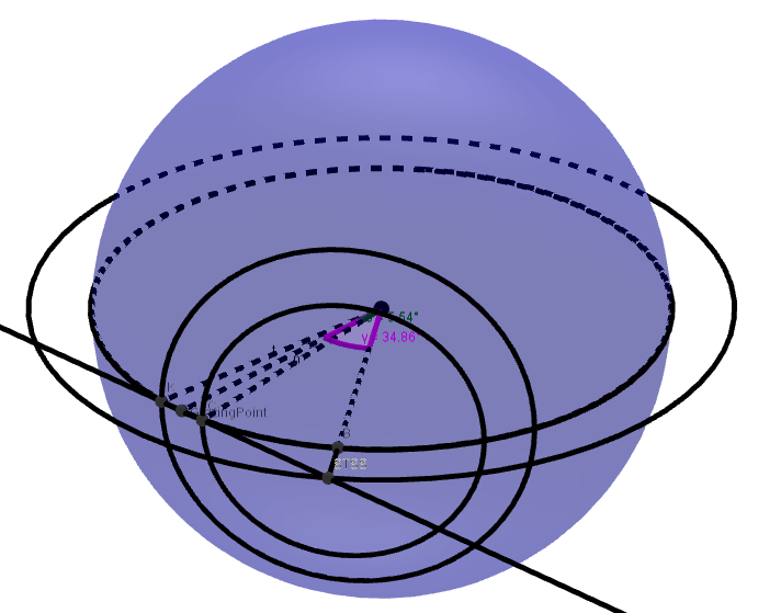
For a missile flying at altitude H, it is seen over the horizon over a band of the earth of width 2α. So α verifies

with R the radius of the Earth. For values of H small compared to R, that reduces to

For H=30 km, that means α=5.6° so each satellite only sees targets over the horizon over a band of the Earth that is 11.2° wide.

The best way to optimize this coverage is to put the satellites as far away as possible, so that this band is as wide as the circumference of the Earth. In practice, putting such satellites in GEO orbit seems to be far enough. To get a full globe coverage against missiles at 30km altitude, 180°/11.2° = 16 satellites are necessary. For stereo tracking, that number has to be doubled. Putting 32 satellites in GEO with large optics, to achieve good resolution and most importantly high sensitivity to track small, cold targets sounds very expensive. Even for the Pentagon and its vast budgets, it might be too much.
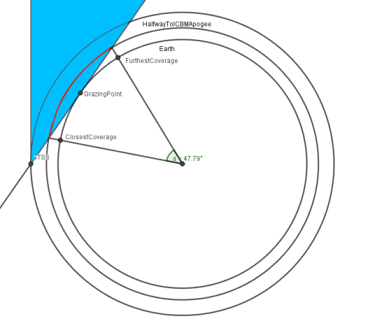
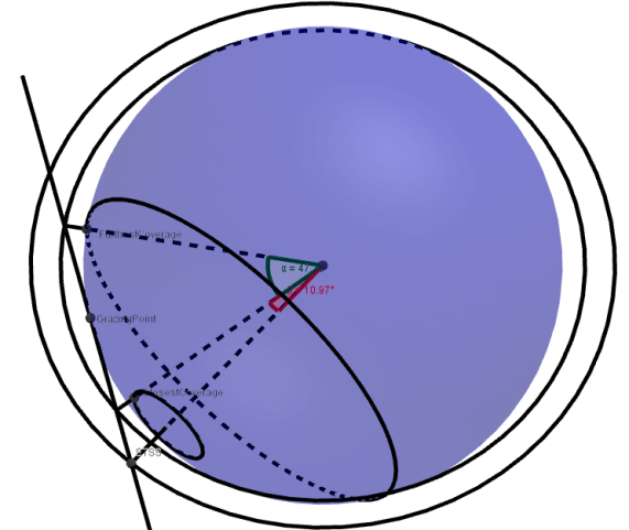
So the other possible solution is not to minimize the number of satellites, but the cost of each individual satellite, and use a low orbit instead of GEO. However, the number of satellites becomes very important. For a satellite in the same orbit as STSS, looking at a missile 30km high, the geometry is the following:
The coverage is the area between the two concentric circles on the surface of the Earth. To achieve full Earth coverage, a ballpark estimate is that 33 satellites are needed per orbital plane for stereo tracking. Each plane would then cover a band 7500km wide, so 3 planes are needed to cover the full Earth. That’s 100 satellites in total. It is surprisingly reasonable, for instance it is much less than the 650 communication satellites Oneweb plans to place in similar orbits. So it seems to be a relatively viable option.
However, this modelling assumes the sensor’s line of sight is blocked only by the Earth’s surface, and not by the lower layers of the atmosphere. If is is the case, the thickness of these layers needs to be deducted from H, and the calculations have to be redone, and if the thickness is 10km or more the number of required satellites will skyrocket.

Conclusion
Looking at public statements made by US officials and at the published data on hypersonic glider temperature, it seems likely a constellation of relatively low orbit satellites with below-the-horizon sensors could provide detection and tracking of those weapons, assuming sensors sensitive enough to detect hot but small targets. It would require tens of satellites, but in the same order of magnitude as previous plans of warhead-tracking satellites, and such a constellation could likely achieve both tasks. In fact, since the initial publication of this article, officials have stated they want to use a LEO constellation plugging into a commercial LEO communication constellation for data backhaul.
Tracking of relatively cold objects inside the lower layers of the atmosphere seems much more difficult, as it would likely require above-the-horizon sensors. This requires either very sensitive thus expensive satellites in geostationary orbit, or a legion of cheaper satellites in low Earth orbit. The number is extremely dependent on the ability of the sensor to penetrate the lowest layers of the atmosphere while maintaining sufficient sensitivity, underlining the fact that sensor performance is the cornerstone of such missile detection systems. Overall, it seems to be a much more risky endeavour, even though the development of commercial megaconstellations might provide the industrial capabilities to manufacture hundreds of satellite buses at a reasonable cost.

Reblogged this on The restless technophile.
LikeLike
This is gold! A great read and the conclusion is thought-provoking. Thanks for writing this.
LikeLike
[…] demonstrated in the article Detecting hypersonics, if you do not have a sensor able to detect and track the missiles over an Earth background, then […]
LikeLike
[…] they are built to detect rocket launches by ballistic missiles, which are lifted into low orbit before plummeting back down to their targets. By comparison, a hypersonic glide vehicle’s rocket only fires for a comparatively short time period, after which it uses its super-speed to carry itself the rest of the way to its target. Hypersonic cruise missiles, which do burn their engines the entire time, are flying low to the Earth. In both cases, SBIRS satellites can’t pick out their heat signatures against the planet. […]
LikeLike
[…] the existing Space-Based Infrared System (SBIRS) satellites face with hypersonic weapons is that they are built to detect rocket launches by ballistic missiles, which are lifted into low orbit before plummeting back down to their targets. By comparison, a […]
LikeLike
[…] weapons are notoriously hard to spot and track. The existing Space-Based Infrared System the Pentagon uses to pinpoint ballistic missile […]
LikeLike
[…] weapons are notoriously hard to spot and track. The existing Space-Based Infrared System the Pentagon uses to pinpoint ballistic missile […]
LikeLike
[…] weapons are notoriously hard to spot and track. The existing Space-Based Infrared System the Pentagon uses to pinpoint ballistic missile […]
LikeLike
[…] weapons are notoriously hard to spot and track. The existing Space-Based Infrared System the Pentagon uses to pinpoint ballistic […]
LikeLike
[…] weapons are notoriously hard to spot and track. The existing Space-Based Infrared System the Pentagon uses to pinpoint ballistic […]
LikeLike
[…] The second family of threats is high-speed, maneuvrable objects, meaning hypersonic cruise missiles and gliders. High-speed hypersonic missiles are nothing new: intercontinental ballistic missiles reach Mach 25 on reentry. However, they are on a ballistic trajectory, meaning that on the rocket has finished burning in the early stage of the flight, the trajectory is completely determined. This makes it easy to determine the target, and to plan an intercept trajectory. Furthermore, ballistic trajectories reach a quite high altitude, making them visible to radar from very far away. Thus, for the hypersonic gliders and rmajet-powered cruise missiles, early warning is a challenge, and interception even more so [Taht is why France is developing the ASN4G]. The generals were considering using satellites to detect these objects, as early warning satellites aimed at detecting ballistic missiles could also pull double-duty for this. More on this and the challenges of detecting hypersonics in this previous article. […]
LikeLike