

Persistent observation, a persistent problem
For all the improvements in spatial and spectral resolution, agility and accuracy, satellites suffer from one serious drawback: they have to follow the laws of orbital mechanics and keep moving around the Earth. This means they cannot hang around an interesting location, to keep a persistent watch on it, except if they are in geostationary orbit.
However, geostationary orbit is so far from the Earth that to get any kind of reasonable resolution (say 1m), huge mirrors are required (20m for a 1m resolution), making this an unworkable proposition in the near term for optical surveillance.
Alternatives exist, in the form of large constellations that always have at least one satellite over the area of interest. This requires on the order of a hundred of satellites: for instance, the Oneweb communication constellation will use around 600 satellites to provide continuous connectivity. So it’s a significant investment which pays off only when the full constellation is deployed, and you get persistent coverage almost all over the globe. Before that, there will not be enough satellites to provide continuous coverage at any location.
This means that these kind of systems only make sense if your customers are all over the globe, which is the case of Oneweb, or if you are interested in looking at many places also spread out all over the world, which is the case for imagery providers such as Blacksky or for the US government for instance.
For other actors with more limited finances and more regional interests, financing a whole constellation does not make sense, it is better to buy access to the data corresponding to the region of interest. However, this might not be possible, either for national independence reasons, or because the commercial market does not offer the right kind of capabilities. For those use cases, there is no good solution to get cheap, tailored and persistent coverage. The closest thing one can get is to fly long-endurance planes with the required payloads. For instance, the USA uses the Global Hawk high-altitude drone for imagery collection, signal intelligence and maritime surveillance. This requires operating at least 3 drones to keep only one on-station, making for a poor productivity.
The rise of HAPS
But things are about to change. Many companies are developing unmanned aerial platforms able to stay on station for month at a time. They are referred to as High Altitude Pseudo Satellites, or HAPS, and can take two forms:
Solar planes
The first one is solar-powered airplanes: since they do not need to carry fuel, they can stay aloft for month, circling over the same spot. They were pioneered by NASA’s Helios project, and Piccard’s Solar Impulse.


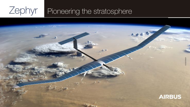
Solar drones have gathered a renewed interest recently, with projects such as Facebook’s Aquila drone, which aimed to provide internet connectivity in remote places. The most mature project seems to be Airbus’ Zephyr, which has had several development variants and is now under production as the Zephyr S. It has a mass of under 75kg, a span of 25m and can carry payloads of up to 12kg at 70 000ft (21km). In 2018, it flew for 25 days non-stop.
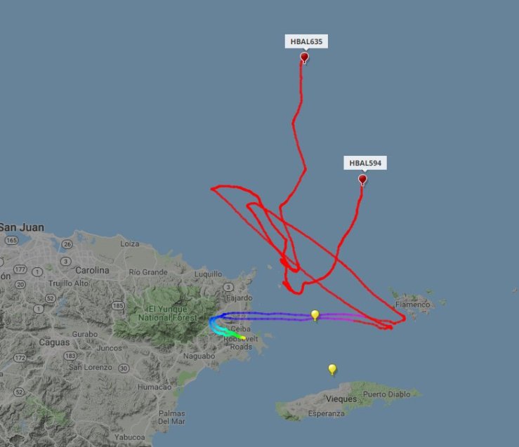
During one of its test flights, a Zephyr with a camera payload acquired high-resolution images of the ground, with a very high resolution :
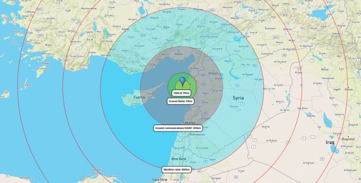
Airbus is developing a larger version, the Zephyr T, that should be able to fly for longer and carry heavier payloads. A presentation at ESA’s 2018 Φ-week showed the coverage different payloads can provide when carried by the Zephyr at 20km altitude:
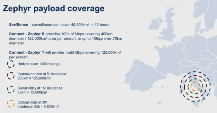
The horizon scan figure is wrong, and should be 500 km for the optical horizon, and 580 km for the radio/radar horizon. The other figures are correct: for optical payloads looking at the ground, the absorption and turbulence of the atmosphere, as well as the constraints on look angle imposed by terrain or buildings, limit the useful range to 35km, enough to cover a city but not a whole country. Still, persistent live video coverage would be very useful for law enforcement.
Balloons
The second possible design to keep a platform in the air for months is to use balloons, such as Google’s project loon stratospheric balloons. Since the lift is provided by lighter-than-air gas, they do not need power to stay airborne, giving them a big advantage. Nevertheless, they need power for their payloads, and also for their engines if they want to stay at a precise position and not drift because of the winds. Even without engines, they can try to stay almost stationary by changing their altitude to catch winds that propel them in the right direction:

The simplest way to maintain position is to use a tethered balloon, but those don’t go very high, so they cannot see or communicate very far, limiting their usefulness. They also cannot operate over water without a ship. So untethered, solar-powered balloons are the most useful design. This is exemplified by Thales’ Stratobus, a 115m-long, 34m wide dirigible able to carry 250kg of payload and provide it 5kW of power:
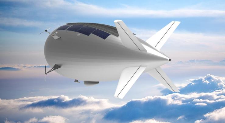
With this kind of performance, Stratobus is able to carry a wide variety of payloads, such as Thales’ 80kg Searchmaster radar, able to perform air and surface search up to 370km away, detect moving ground targets, and build detailed SAR and ISAR pictures. Heavy optronic turrets, like Safran’s 16″, 53kg Euroflir 410, can also be used.


With a much larger capacity than solar planes, dirigibles like Stratobus can perform a wider range of missions, from telecommunications to radar and optical observation, and including signal intelligence.
Sample scenarios
In order to demonstrate the usefulness of a HAPS platform, here are a few example scenarios:
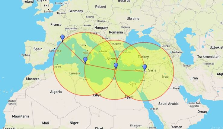
Mediterranean maritime surveillance
With the current migratory flows into Europe from Africa and the middle East, it is critical to be able to track migrant vessels crossing the Mediterranean, both to organize rescue operations at sea and to respond to successful landings. However, to keep a watch over this large area, European states have to rely on short-range radars carried by boats, or on radars aboard maritime surveillance aircraft with a limited persistence time.

With 6 HAPS operating a 20km, and a radar range of 400km, a search barrier can be maintained over the Mediterranean, from Morocco to Egypt. Detection from the HAPS can be used to cue other assets, such as planes or helicopters to perform identification, or rescue vessels. Using imaging radars with SAR or ISAR would add some identification capability to the HAPS and decrease the need to cue other sensors. Adding an AIS receiver alongside the radar payload would make discrimination between standard commercial traffic and migrant vessels much easier for a negligible power and mass penalty. With the same equipment, the HAPS could also act as a VHF relay, providing an over-the-horizon voice channel to vessels within its 580km radio horizon.
Communications
With a few HAPS, it is also possible to set up a communication network over a whole country, with each HAPS acting as a 20km high mobile phone tower and providing near-perfect coverage over a 200km range. This might not be competitive with a cellular ground network in regions with a high subscriber density, but offers an easy and quick way to offer coverage for sparsely populated regions. Compared to relying on satellite communications, HAPS offer lower latency, and a much better link budget: because they are 200 times closer than a geostationary satellite, user terminals need 400 000 times less power to talk to them, enabling the use of phone-like terminals with omnidirectional antennas, that can work on the move. In that sense, such a HAPS network would be a strong competitor to LEO satellite networks like Iridium.
In addition to the civilian application, this also has military applications: an communication network with long range and small user terminals is very useful for ground forces operating far from their bases. In conflicts like the war against the Islamic state in Syria, setting up a few HAPS in international waters and in neighbouring countries would give long-range communications to troops operating inside the country. Besides, the same HAPS could carry signal intelligence payloads with the same range as the communication payloads, and in that case would be able to detect emitters and listen in on mobile communications over most of the country.
Ground surveillance
To stay in the context of security applications, HAPS can also provide a persistent surveillance over ground, be it 24/7 with radar or only in cloudless weather with optical sensors. For wide-area surveillance, radars have an interesting property: by using the Doppler effect, they can very easily filter out terrain and static objects, and detect only moving objects. This is called a GMTI (Ground Moving Target Indicator) mode. With such a mode, a HAPS with a GMTI radar can detect all cars in a radius of 70km. This is a larger range than what can be achieved by optical sensors, which are be limited by the atmosphere at high incidence angles, and can only see at 20 km for a 45° off-vertical angle, or 35 km for a more aggressive 60° off-vertical angle.

However, optical sensors still have a place: they can be used over points of interest like cities. Since HAPS move much slower than a typical surveillance drone, and are consequently much less responsive, they have to be positioned in advance. Besides, in urban areas, building are a source of obstruction and hide what happens in the streets, so look angle have to be closer to vertical than in the countryside. The higher the building, the worse the obstruction will be.


Signal intelligence
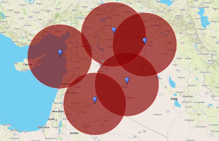
As can be seen from the examples above, a HAPS offer a mounting point for all kinds of surveillance payloads, from radars to signal intelligence receivers. The latter have a big advantage: since they are passive and only need signals to do a one-way trip, they can have lower power consumptions and longer ranges that radars. To give an idea of how useful a HAPS can be for strategic signal intelligence collection, here is an example with one off the coast of Syria:
Optical sensors can keep watch over one port, with the radar looking over the coastal areas and up to 400km away over sea. Line of sight obstruction restricts the communications and high-frequency signal intelligence range to 200km over land using the 5° incidence angle criteria from Airbus, but that is a very conservative criteria to ensure all subscribers of a communication service can be reached at all times. The actual lines of sight can be computed and show coverage much further out:
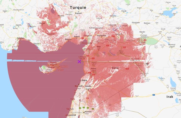
The optical lines of sight extend to around 500km, which is the theoretical radio horizon. This is the case because apart from a mountain range near the sea, the Syrian terrain is quite flat:

Consequently, in this case, for emitters located on a vantage points like radars or cell phone towers, and for shipborne emitters, the relevant range is the theoretical radio horizon, which is at 580 km:
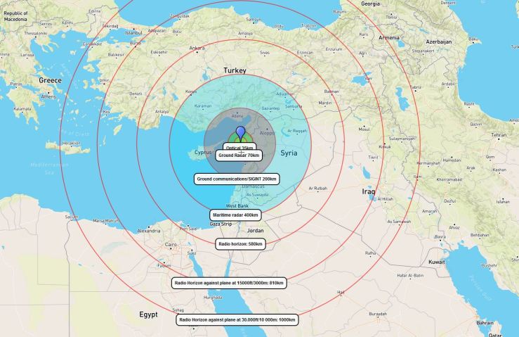
The radio horizon against flying targets is even further away, at 810km for targets flying at 3000m, which gives coverage all over Syria and part of Irak. For target flying at 10 000m, like most jets in transit, the horizon is at 1000 km.
Detections from the SIGINT system can be used to cue narrow field of view sensors, such as a radar in tracking mode.
Overall, HAPS shine as a signal intelligence platform, and especially dirigible HAPS, as they are less sensitive to payload volume and should have space for more or larger antennas. The main limitation to this use might be that most countries will not take kindly to a listening post posted at the edge of their territorial waters, and that could have diplomatic or worse consequences.
Data backhaul
All these surveillance applications generate large amounts of data, which can be downlinked directly in theater, within the communication footprint of the HAPS, and exploited there. If the data has to be transmitted further away, it can be done directly from the HAPS, using a laser link to a geostationary satellite for instance, or a more conventional radio satellite link. The HAPS can also act as their own backhaul communication link: since from their 20 km altitude the radio horizon is 580 km away (500km for optical horizon), this means a “hop” from one HAPS to another can be up to 1160 km long (1000 km for optical) . This means that only 3 hops and as many HAPS (in addition to the one collecting the data) are needed to cross the Mediterranean for instance:
Depending on the cost of a HAPS relay and on the distance to cross, using HAPS for backhaul might be cheaper than using satellite communications. Compared to using commercial optical fiber cables, it can be redeployed depending on the need, and offers a sovereign solution than can be hardened against jamming and intercepts since the links between the HAPS can be very directional.
Conclusion
High-altitude pseudosatellites can provide localized persistent surveillance over land and sea, for a fraction of the cost of a satellite constellation. While HAPS carrying only optical payloads have limited mobility and thus can only keep watch over one spot, larger models able to carry advanced multifunction radars have a much larger field of view, especially over sea, making them interesting for coastguard applications for instance. HAPS also make ideal signal intelligence platforms for long-range, long-term collection. Their first application however may be providing communications in sparsely populated area, with operators addressing this market first and Earth observation second. Still, they can be expected to become serious competition to observation satellites in some niche use cases.

Reblogged this on The restless technophile.
LikeLike
ISAR functions to be provided for disaster relief and ecological protection would likely increase the attraction for nations with limited budget and yes, as force enhancer during conflicts.
LikeLiked by 1 person
[…] beam 5G down to Earth from satellites in the Earth orbits, from networked civil aircraft, from pseudosatellites in the stratosphere … In other words, from everywhere. The stated plan and the word trumpeted in […]
LikeLike
[…] Der Plan sieht vor, 5G von Satelliten in erdnahen Orbits, von vernetzten Zivilflugzeugen, von Pseudosatelliten in der Stratosphäre auf die Erde zu beamen… Mit anderen Worten, von überall […]
LikeLike
[…] sieht vor, 5G von Satelliten in erdnahen Orbits, von vernetzten Zivilflugzeugen, von Pseudosatelliten in der Stratosphäre auf die Erde zu beamen… Mit anderen Worten, von überall […]
LikeLike
[…] and the constellation will have to compete for limited funding against other solutions such as pseudo-satellites or even tethered drones and […]
LikeLike
[…] The first roundtable was focused on the various projects in development by French companies. The first speaker to take the floor was the CEO of Thales Alenia Space, which is developping the Stratobus high-altitude maneuvrable balloon. Stratobus is a 115m-long dirigible able to fly in the stratosphere, where the winds are relatively moderate compared to lower altitudes. To keep on station, it is covered in solar cells that power electric motors. I covered it in detail in this previous article: […]
LikeLike
[…] Thus, it has a very strong position as not only a successful smallsat provider, but also in the pseudosatellites sector, where light, radiation-tolerant, long-lasting solutions are also […]
LikeLike