

This article initially appeared on eastpendulum.com, a French-language blog about the Chinese military and aerospace industry
The Chinese Yaogan-30 constellation has already been the topic of two previous articles, but this one is probably the last: with the launch of the seventh trio of satellites, the constellation has now six equally-spaced planes, so it has reached its full capability.
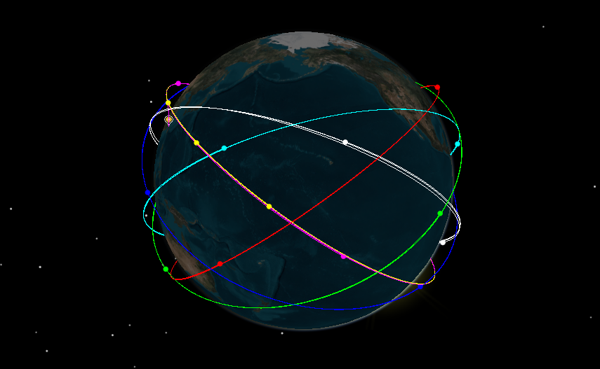
Now seven launches for only six planes should raise questions. As outlined in the previous article, the third and fourth launches went into the same orbital plane and created a “train” of 5 satellites quickly following each other, providing very high-frequency revisit when the train passes over an area of interest.
Dead satellite
The other peculiarity of the constellation is that one of the satellites of the sixth group failed, or at least its propulsion failed: Yaogan 30T (international designator 2020-021C) is not phased correctly in its plane. Normally the three satellites in a plane are phased 120° apart to maximize coverage, but currently Yaogan 30T and Yaogan 30S are very close to each other, making one of the two redundant.
The redundant one is 30T, as can be seen by comparing the orbital elements of the sixth trio:
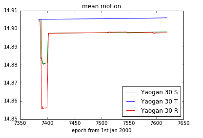
30T has not maneuvered at all since reaching orbit and consequently does more revolutions per day (called mean motion) than the other two, meaning its is constantly moving around in the orbital plane. The fact that it is close right now to 30S is a coincidence, it will move further and further apart over time.
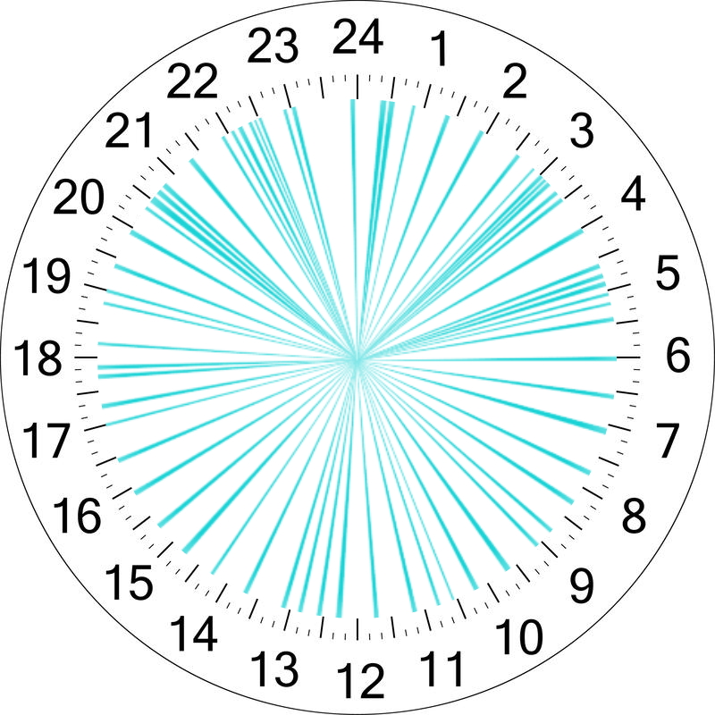
Compare to what happens in a fully-functional trio, in this case the for the latest launch:
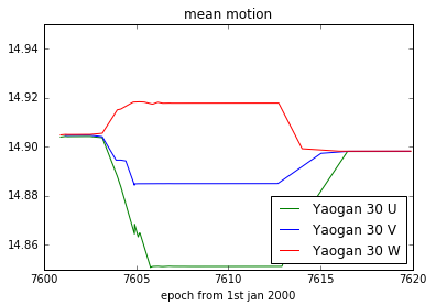
The satellites were launched together so at the beginning the curves are on top of each other. Then, they maneuvered to have different revolutions per days, in order to move to a different angular position on the orbit. They drifted until this position reached the required 120° phase. Finally they maneuvered again to freeze the orbital configuration, by adjusting their orbits so that they have all exactly the same mean motion. That ensures they are synchronized and stay that way.
It is possible China will replace the failed satellite, because it would the coverage offered by the constellation more consistent, with less gaps. That would be a good fit for one of the small launch vehicles such as the CZ-11, since a single Yaogan-30 satellite is a fairly small payload.
Coverage
Speaking of coverage, let’s look at what the constellation can do. Given the inclination, it is optimized to look at countries close to China, especially on the Pacific coast. So Taipei, the capital city of Taiwan, is a very representative target, especially with the recent tensions and rearming effort by the Republic of China.
Based on how the 3D models of the satellites look in Chinese TV images, they do not seem to be carrying a radar or an optical imaging payload, so they probably do signal intelligence, with maybe a communication role too. These kinds of payload do not need a high incidence angle to work, 5° is often enough. Under this assumption, the coverage at Taipei is the following:
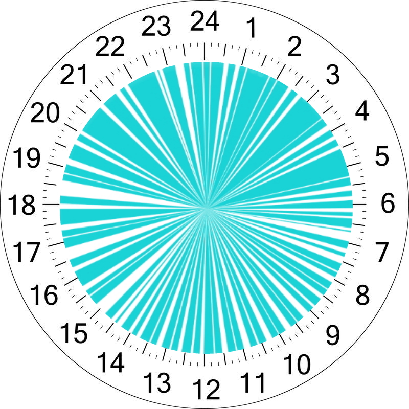
So over a 24h window, the coverage is almost constant, with the biggest gap being around 30 minutes, and most gaps being 10 minutes every half an hour. The following video shows the position of the satellites and the coverage opportunities (as a purple link between the satellite and the ground) over time:
On the other hand, if we assume the satellites carry an imaging payload, more constrained incidence angles are needed, and that reduces coverage. Assuming 30° incidence is required, it then becomes:
The result is much more sparse, which logical since each individual satellite needs to be much higher above the horizon to be able to image. However, there is still a very frequent coverage, with imaging opportunities roughly every 30 minutes. That allows for almost persistent imaging, and would give China the ability to keep adversary mobile assets, such as missile launchers or ships, at risk.
Future plans
That frequency is already the highest of any known constellation in the world, but China plans to take things further, as explained by academician Li Deren in a recent interview:
“The first step is to make a local (local) coverage from the South China Sea to the North China region. This requires about 20 remote sensing satellites and 1 to 3 geostationary orbit communication satellites to achieve a time resolution of 15 minutes. High-resolution target images and sub-meter navigation and positioning accuracy are sent to users’ mobile phones and other smart terminals;
The second step is regional coverage of China and surrounding countries along the Belt and Road. This requires about 100 remote sensing satellites. Among them, half of the remote sensing satellites are optical satellites and half are radar satellites to ensure that there are images during the day and night, plus 150 communication satellites;
The third step is global. If you want to achieve global service, it is estimated that 200 remote sensing satellites and 300 communication satellites are needed. The service index is the time resolution of 5 minutes, that is, the required image target is found within 5 minutes, the resolution and navigation accuracy reach 0.5m, and the on-orbit processing and communication time is less than 1 minute before being delivered to the user’s mobile phone.”
Yaogan-30 corresponds to the first local step, with 21 satellites on an inclination optimized for the Chinese littoral. However, it does not achieve 15 minutes revisit, so maybe Mr Deren is talking about another constellation to be orbited in the future. The use of geostationary satellites to serve as data relays and minimize the latency of the system might already be implemented on Yaogan-30 though.
Li Deren also explains that future developments will integrate the traditionally separated functions of observations, communications and location services, and provide this data directly to end-users’ phones to minimize latency and thus maximize its impact:
“provide users with the function of PNTRC-P (position) represents position, N (navigation) represents navigation route, T (time) represents time, and R (remote sense) represents remote sensing Image, status, C (communication) stands for communication, that is, this information can be sent to the receiving device in your hand”
This plan is strikingly similar to the American plans led by the Space Development agency, which is currently procuring the first satellites for a multi-layer communications, missile warning and observation constellation. Given the large Chinese efforts in this area, they will undoubtedly succeed in developing an equivalent system, and thus it is not the last time we hear about large constellations of Chinese satellites.

[…] a zero cost per shot is a very interesting counter to the military smallsat constellations that are becoming […]
LikeLike
[…] This article initially appeared on eastpendulum.com, a French-language blog about the Chinese military and aerospace industry The Chinese Yaogan-30 constellation has already been the topic of two previous articles, but this one is probably the last: with the launch of the seventh trio of satellites, the constellation has now six equally-spaced planes, so it has… — Read on satelliteobservation.net/2020/11/25/china-completes-the-yaogan-30-constellation/ […]
LikeLike
[…] has created a Yaogan 30 satellites constellation of six equally-spaced planes. With their 35° inclination, Yaogan 30 satellites are optimized to look at countries close to […]
LikeLike
[…] 8-ją kinai lėkdino net 3 Long March startūnus 19 val laikotarpiu su 47 satais Yaogan (lyg karinės paskirties) bei TJSW-22. Long March jau kilo 600 kartų. Gi gruodžio 9-ją Tiangun […]
LikeLike