

There has been a recent change in French military space policy: high-level officials have starting floating the idea of a constellation of small satellites to support military operations.
First, there was the report on the role of the defense industry in the post-COVID stimulus plans, in which the head of Space Command stated (p.14) that “developing a constellation of nano- or mini-satellites in low orbit, in link with emerging actors in the space sector” was in his top four short-term procurement priorities. The commander went on to say “the benefit of such an architecture is the frequency of revisit of a given point of the Earth, with very limited costs and a much better risk resiliency compared to relying on a single satellite. “
That was confirmed by an intervention of one of his subordinates, Colonel Rigal, who stated during a space industry forum that introducing constellations to increase resiliency and bring multi-mission capabilities was in the top 3 items of the command’s 10-year roadmap:
The recently published Defense Innovation Orientation Reference Document (DROID) from the Defense Innovation Agency also mentioned that CELESTE, the next-gen satellite ELINT project, will “explore the potential of small satellites and low cost components for intercepting certain signal from space and profit off the emergence of new actors and commercial services” (p.11)
Finally, in an interview focusing on preparing for a high-intensity conflict, the new Chief of Staff of the Army outlined the role of satellites to find targets for the Common Indirect Fire Support (CIFS), to dismantle enemy area denial bubbles.
An expected change
All of this this should not come as a surprise to people familiar with the Earth Observation industry. Firstly, smallsat constellations have been very popular in the commercial sector to increase revisit at a reasonable cost, as outlined in a previous article. Planet, Skybox and Blacksky have pioneered it in the optical sector, and many startups are planning to do the same for SAR satellites: Iceye and Capella already have a satellite in orbit, and Umbra Labs and PredaSAR are not far behind.
Furthermore, the more general military space policy changes recognize space as a contested domain and put the focus on developing resilient capabilities. Thus, putting many cheap platforms on orbit allows for a more graceful degradation in case of an anti-satellite attack. Whereas losing one satellite in a system of two very expensive platforms is a huge blow, losing only one is a constellation of twenty is almost nothing.
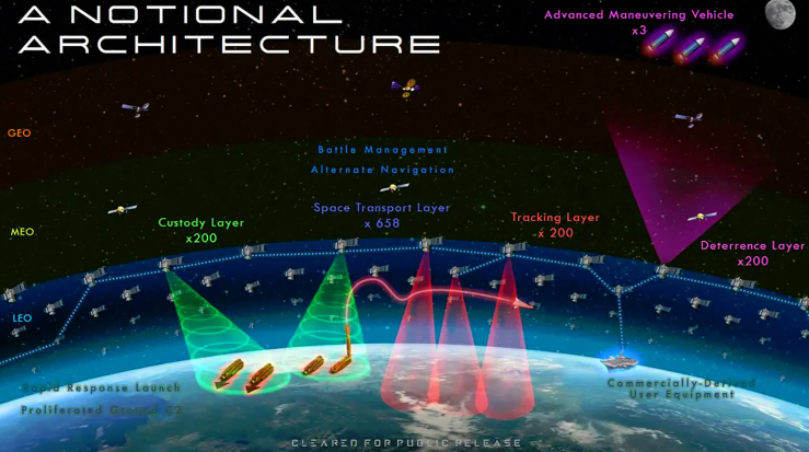
Consequently, smallsat constellations are very attractive for military use. In fact, the USA are developing one right now (in addition to the NRO ones we do not know about), under the aegis of the Space Development Agency. This constellation will provide communications in addition to Earth Observation, and all of the satellites will be networked with laser crosslinks. Russia is considering one under the Sfera project (some more details). China already has a military smallsat constellation on orbit, called Yaogan-30, with already 18 satellites, presumably for electronic intelligence.
A constellation yes, but to look at what?
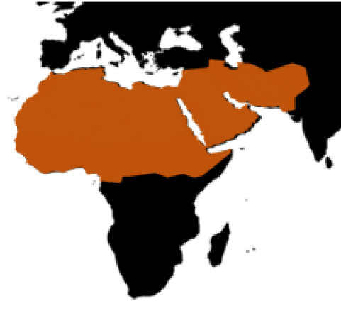
Such a constellation would need to fit within France’s defence and security strategy. Over the years, several Defence white papers have defined the area of interest for France to be the “Arc of Crisis” going comprising the upper half of Africa and the Middle East up to Afghanistan.
This area is among other things, the specification for the high-priority Area of Interest for the future CO3D imaging satellites, which will provide the French Ministry of Defense a very accurate digital elevation model.
However, it is not fully representative of the current geopolitical situation: for instance, Turkey, which is having right now a tense confrontation with Greece and France with shows of force on both sides, is not included. Neither is Eastern Europe, even though following the Russian annexation of Ukraine, a significant French diplomatic effort has been to punish this behaviour and to provide reassurance to European Union member states that are worried about Russian expansionism. This is not only diplomatic, the aforementioned effort by the Army to strengthen high-end capabilities is precisely aimed at a conventional conflict with Russia in eastern Europe. So the area of interest is actually the borders of Europe: the southern one, which is the Mediterranean and northern Africa, and the eastern one, from the Baltic states to the middle East.
Among this region, three different types of military operations are likely in the future:
Counter insurgency in northern Africa
The first one is the continuation of stabilization operations in northern Africa, more precisely in the Sahara-Sahel Band. France has had a military presence in the region since its former colonies gained their independence, and has been conducting such operations for about as long. The latest was launched in 2013, as a counter-offensive to prevent djihadists from taking control of Mali. Operation Serval saw a quick surge of force to push back and then dismantle djihadist strongholds, and has since then evolved into Barkhane, with peacekeeping and small-scale engagements replacing the large combined arms offensive.

Barkhane and similar operations are likely to continue in the near future, and in the longer term climate change will create food shortages and refugee movements in the tropical bands, making the situation even more unstable. Thus, the needs associated to these operations are here to stay. They can be separated in two categories:
- Long-term intelligence needs, to keep watch of suspicious activities even when the tensions are low. This entails for instance monitoring movements in various towns and outposts.
- Providing battlefield intelligence during engagements by French troops at operational and tactical levels. For the tactical level, it is much better done with drones than with satellites, as they can provide live, very high resolution imagery for hours at a time, without interruption. At the operational levels satellite can be useful: the Pleiades high resolution satellites were used during Serval to see what was happening in djihadist bases.
In both cases, the objects of interest are buildings, personnel on foot and the local means of transportation, ie pickup trucks. The adversary has no counterspace capabilities apart from camouflage.
Near-peer conflict
Up a step on the intensity ladder, we have a potential conflict with a regional power. The recent escalation with Turkey shows it is not a far-fetched possibility, and that France might not always have a large coalition at its side. More limited engagements against heavily-equipped enemy forces are also possible, for instance in Libya, which is turning into a free-for-all between Russian, Emirati and Turkish forces, involving planes, drones, air defense and so on.
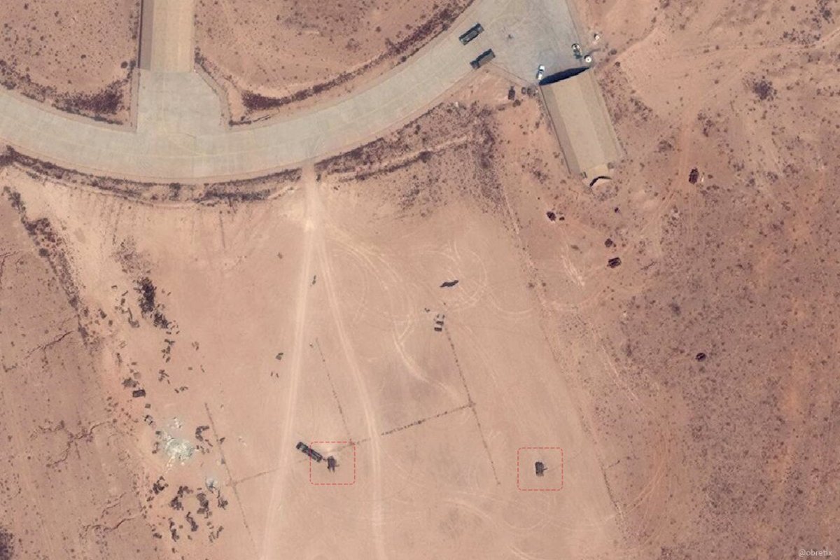
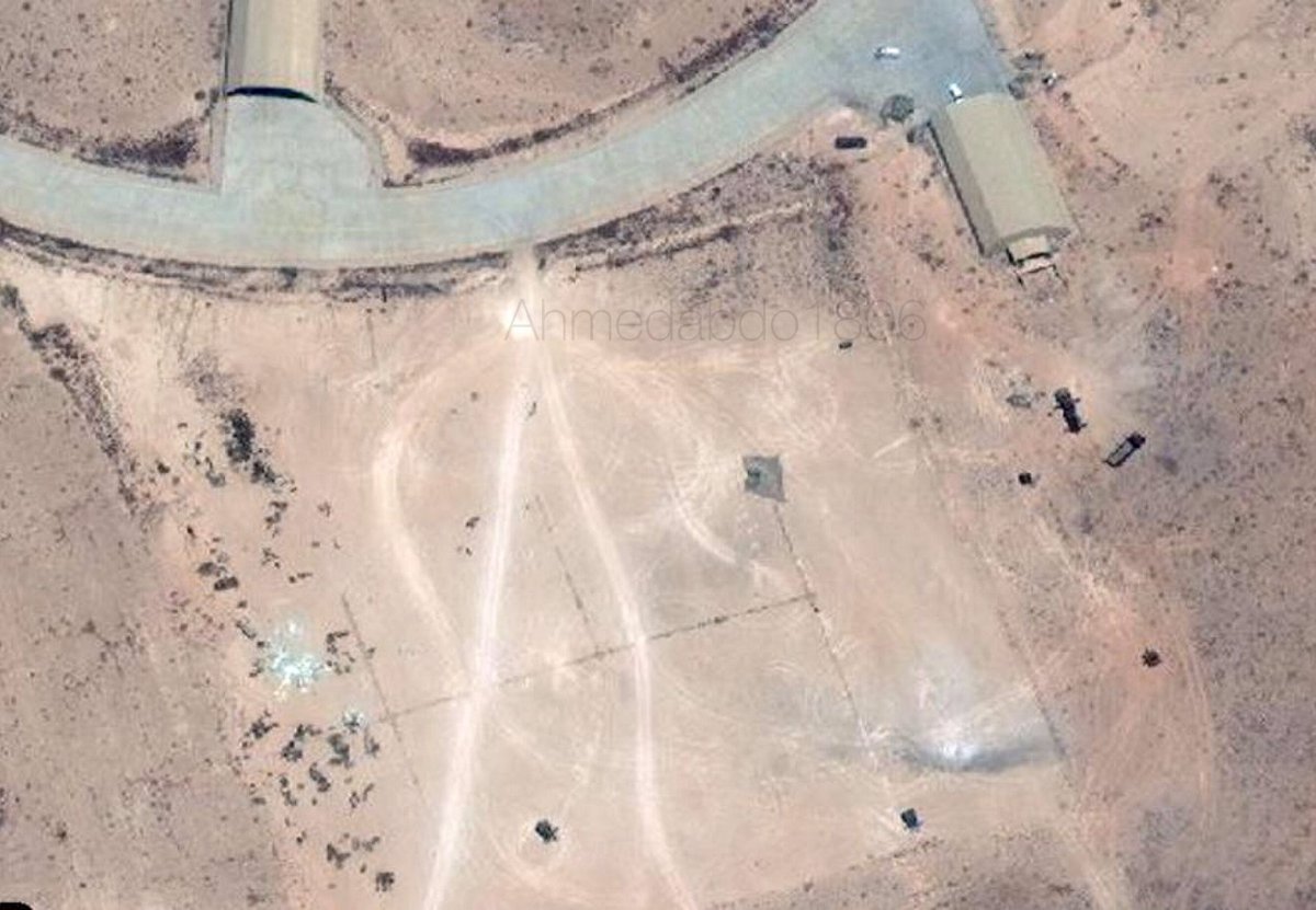
In such a scenario, there is a need to keep tabs on enemy forces before the shooting starts, by keeping watch of known deployment locations and identifying what vehicles are there. During a conflict, the benefits of imagery would be to provide fresh targeting information, for instance by indicating which shelter in an airbase have planes inside them. Reactive Bomb Damage Assessment (BDA) is also important: the cruise missile strikes against Syrian chemical weapon sites on April 13th, 2018, were synchronized with satellite passes to see if they were successful.
The counterspace capabilities of such adversaries are presently limited, but might include radiofrequency jammers against SAR satellites. In the future, they might be stronger, potentially including laser dazzlers. However regional actors will probably not have access to kinetic ASAT.
Conventional conflict against Russia
The highest intensity conventional scenario, and the one that is pushing the Chief of Staff of the Army to change the way it will train, is a large-scale conflict against Russian forces in Eastern Europe. It is not something where France would be alone. Rather, there would be a coalition of European states (eastern and western) and hopefully the United States. It could occur as a Russian invasion of the Baltic states, but Poland is also clearly worried about a Russian attack on its soil.

Since Russian forces are very mobile, and their radars and missile systems are relocatable, striking them is a tough challenge. A rough position of enemy radars can be obtained when they are emitting, but the uncertainty might be too large to engage them with unguided munitions, or even with guided munitions if the uncertainty is larger than the field of view of the seeker. Missile sites are even harder to detect. Since all of those are expected to reposition often to make targeting information outdated, there is a need for an extremely short sensor-to-shooter OODA loop, and for assets able to look a hundred of kilometers or more behind well-defended enemy lines. This is what is leading Poland to consider stealth UAVs as part of its Harpy Claw program, for target designation to its recently purchased MLRS force. This is also precisely the type of problem the future artillery system is expected to face, and for which the Chief of Staff of the Army proposed using satellites.

On the counterspace front, Russia enjoys the full range of capabilities, from direct-ascent and coorbital ASAT, to jammers, laser dazzlers and even more: the Peresvet mobile laser system has such a large aperture and power plant that it might be able to damage targeted satellites. For now it is reserved to defending the mobile ICBM force, but a future version could be deployed on the battlefield. Long-range strikes against fixed satellite ground stations must also be expected.
Constellation design
Based on the scenarios above, very high-level requirements can be drafted for the constellation:
- It must be able, when cued, to identify and accurately locate military vehicles, and quickly pass this information to relevant commanders for a strike.
- It must keep up with the operational tempo by having a high refresh rate in actual use, taking into account weather, repointing speed, etc…
- It must be resilient to at least basic counterspace capabilities such as jammers, laser dazzlers and a few well-placed kinetic ASAT shots
The focus is on the near-peer and high intensity scenarios, since in the counterinsurgency use case the main need is persistent live imagery at very high resolution, which a reasonably priced constellation cannot provide.
The ability to perform uncued search would also be useful, but implies an extremely high combined swath, while keeping an acceptable resolution, and would make optical systems very expensive. It should be possible to achieve wide swath with SAR however. Nevertheless, high swath systems are inherently very sensitive to jamming, and low-resolution SAR can be fooled by simple decoys such as repeaters or corner reflectors. So the best option for uncued search is probably emitter-location satellites, which have their own set of limitations: they will be no good against forces under emission control or with low probability of intercept datalinks. But ground-based platform could also provide electronic intelligence to cue the constellation, so I did not put uncued area search as a requirement.
Tradeoffs
Sensor type
Perhaps the most important decision is what sensors to use in the constellation. It has implications on the coverage provided and on the cost of the sensor and of the bus. The options are optical, SAR and passive electronic intelligence receivers.
A strong constraint on optical satellites is that Eastern Europe has poor weather, especially in the winter. Here is the cloud cover derived from Sentinel data:
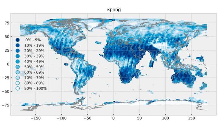
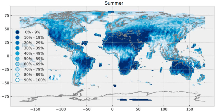
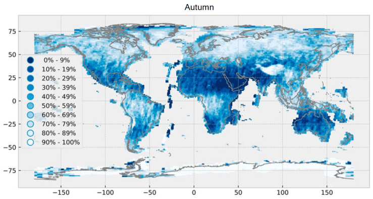
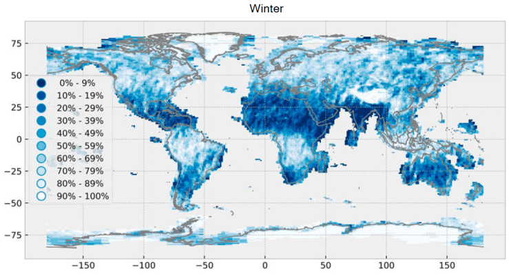
While clouds are mostly nonexistent in the Sahara-Sahel band, and very light around the Mediterranean, there is very little sunlight over Poland and the Baltic states in the winter. This is further compounded by the fact that the data above is an average: a bad weather system can result in a 100% cloud cover for a few weeks, so optical systems cannot be relied on if Russia picks the time to start an offensive. SAR does not have that problem.
Another limitation of optical systems is that they do not see at night, unless there is a thermal infrared channel added. Those suffer from a degraded resolution though, and are usually expensive.
The different pros and cons of optical, SAR and ELINT sensors are summed up in the following table.
| Optical | SAR | ELINT | |
| Pros | Good resolution Easy to interpret COTS sensors & optics | Works 24/7 Can have wide swath modes | Works 24/7 Extremely large swath Little clutter, relevant targets stand out |
| Cons | Does not see through clouds Needs thermal IR to see at night | Harder to interpret | Worse geolocation accuracy Useless if the enemy does not emit towards the satellites |
| Scenarios suitability | Near-peer Conventional conflict against Russia in summer and spring | Near-peer Conventional conflict against Russia (both with counter-counter measures) | Near-peer Conventional conflict against Russia |
I put a caveat on SAR, since it is relatively easy to jam a SAR satellite with an omnidirectional emitter, whereas to dazzle an optical satellite you need to have a laser precisely pointed at the satellite for the duration of the pass. Nevertheless counter-countermeasure exist for SAR, for instance by emitting a pseudo-random signal at each pulse, but the race with counter-counter-counter… measures is never ending.
Inclination
Because of the weather, it could be tempting to put an optical constellation in an relatively low-inclination orbit, at 39° for instance, so that it passes over Turkey but not over Eastern Europe. By comparison, to image up to the Baltic states, a 53° inclination is required. The choice of inclination is very important, as a constellation provides a very high revisit rate in a small latitude band just under the value of the inclination:
| passes/ 24h | 39° constellation | 53° constellation |
| Tallin (59°) | 0 | 24 |
| Kiev (50°) | 0 | 97 |
| Ankara (39°) | 77 | 67 |
| Tripoli (32°) | 103 | 39 |
| Gao (16°) | 49 | 24 |
This is for a Walker 24/12/6 constellation, with 12 planes each having two satellites at 500km altitude. Access is computed for a 60° viewing angle (which degrades the resolution by 2 for optical satellites).
The 53° constellation also has the added benefit that its line of sight goes very high up North and covers the whole Scandinavian peninsula. This would be very useful to keep watch of activity in Murmansk with electronic intelligence. For the 39° constellation, the ELINT line of sight covers Eastern Europe up to Tallinn, but always from the South, so radar beams pointed towards the West would not be intercepted.
Interestingly, the recent American NROL-129 launch seems to have placed two groups of ELINT satellites in a 54° orbit, proving it is a good choice to look at China and Russia. The Chinese picked 34° for their Yaogan-30 constellation, as it allows them a very high revisit over their neighbours.
Number of planes and number of satellites per plane
For a given budget, and thus a given number of satellites, there is a choice to be made between having a few orbital planes with a lot of satellites each, of a lot of orbital planes with few satellites. The first one gives a “burst photography” effect: once a plane passes over the area of interest, the satellites will arrive in quick succession and take image every few minutes, creating almost a video of the target area. However, since there are few planes, the next ones only passes over in a few hours, so there are long gaps in coverage between those videos. Also, if the weather is bad for one satellite, it will be bad for all the other satellites of a plane, resulting in a lot of wasted opportunities.
Spreading out the satellites on more planes reduces those gaps in coverage: instead of a few movie clips, you get static images, but delivered regularly. That is probably more useful for the scenarios above, since it does not constrains the operational tempo: there will always be recent information available. The limit of this approach is that at some point, if there are to few satellites per plane, some planes will not result in an imaging opportunity because the ground track will not pass close to the target.
This is why 12 planes with 2 satellites at 500km altitude each were chosen above: each plane ensures 2 passes (one at night and one during the say) at low latitudes for the 53° constellation. That gives a pass every hour, and much more at high latitudes.
It is not completely true that cost depends only on the total number of satellites: having more planes means either doing more launches to directly inject satellites in them, or putting the satellites of several planes on the same launch. In that case, some will have to raise their orbit, precess to move to the adjacent plane -which takes time-, and lower their orbit again.
To crosslink or not to crosslink?
Commercial LEO communication constellations often have satellite crosslinks, so that information can be relayed to the end user instantaneously, without having to wait for a pass of the right satellite over the right ground station. Most of the time it is achieved by having all the satellites of the constellations act as relays, although some architecture rely on separate relay satellites in GEO. It is the case of Pléiades Neo and Copernicus for instance. These use laser crosslinks which provide very hard throughput and are impervious to jamming, making them very well suited for a military constellation, so much so that it is what the USA are going to use for theirs.

However, there are drawbacks to crosslinks in general:
- relying on a few GEO assets is not very resilient, so the constellation must be its own relay instead
- this only works when there is a large number of satellites in the constellation, so that they are in view of each other.
- crosslinks are expensive, so much so that the initial Oneweb and Starlink constellations do not use any
The alternative to crosslinks is to have satellites that can be tasked by forward ground stations as they emerge over the horizon, and can downlink their images to the same ground stations while they are imaging. This already exists in the form of direct receiving station, but it does not work if the targeted area is far from a friendly territory with a secure backhaul to the command centers.
Industrial aspects
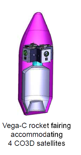
The French industry is in a good position to build a constellation. First of all, it has access to a small launcher to orbit pathfinders a even put a plane or two at a time. That is Vega C, with a performance of 2400kg to 500km SSO (slightly more more for less inclined orbits), at a price of around 40M$. For very large deployments, Ariane 62 will have more carrying capacity, probably a lot more than is needed, at a higher price. Both launchers ensure independent access to space.
On the satellite side, a lot of the capacity is already there:
- Airbus is building the Arrow platform for the Oneweb constellation, and has reused it for the CO3D optical satellites. Those will weigh around 300kg and have a 0.5m resolution, enough for recognition of vehicles. Airbus management is touting them as a first step towards a larger constellation.
- Thales Alenia Space has a joint venture with Blacksky to produce their small optical satellites. Currently their resolution is 0.9m for a mass of 50kg, but the next generation will reach 50cm and have thermal IR capabilities. These will be developped for and operated by the US Army.
- On the smaller end of buses, Hemeria is a newcomer to the field but has thanks to the help of CNES launched a first 12U satellite, but is developping larger platforms up to 65kg. It already has a contract to build a constellation of IoT smallsats
On the sensor side, Airbus and Thales already have an expensive experience in building high-end optical imagers: Airbus builds the CO3D and Pleiades Neo imagers in-house and Thales has built the imagers for Pleiades first of its name and the optical and thermal IR payloads for French military satellites. Thales also builds SAR payloads for South Korea with large deployable antennas. On the smaller end, other companies such as Safran are producing optical and infrared imagers for ground applications, and have designs for space-based ones: Safran has already designed a 8U payload able to provide 1.5m resolution from 500km. This is a bit to coarse for vehicle recognition but is a good first step.
Finally, the large amount of data produced by a constellation will be too much for human analysis. Even with the current imagery, DRM, the military intelligence agency is overwhelmed by data and can only look at a fraction of what is collected, and the constellation would bring one or two order of magnitude more. So automated exploitation is paramount, at least as a first step to only show what is relevant to human eyes. In this context, France luckily has a few companies in this sector such as Earthcube, which specializes in automatic object detection and identification. DRM has also a military AI project in the works called ARTEMIS which will provide large-scale storage and compute power.
Conclusion
Recent statements by French military officials hint at the development of a constellation of small satellites for military use. If it pursues this opportunity, France would follow the path of the other major space powers and obtain a resilient system able to give an edge in a high-intensity conflict, by providing frequent intelligence on enemy positions. French industry is well positioned to build small satellites with high-performance sensors, however the choice of the type of sensor will raise difficult compromises, and the constellation will have to compete for limited funding against other solutions such as pseudo-satellites or even tethered drones and aerostats.

[…] need to use intelligently the IRIS2 project of the EU commission. We are also trying to improve our revisit capabilities for observation as part of the CHRONOS project. But we will keep investing into extremely high […]
LikeLike
[…] a sovereign and secure constellation, and a proliferated observation constellation has as much military importance as a communications one. With the large number of both established players and startups in the […]
LikeLike
[…] fills most of the role outlined in The case for a French military constellation: a high-revisit, low-latency system for tactical use, at a reasonable price. A further step could […]
LikeLike